
Ultra-High Voltage (UHV) transmission lines form the backbone of cross-regional power delivery in China. A significant portion stretches across rugged mountains, high-altitude plateaus, and uninhabited wilderness. Traditional manual inspection cannot handle such terrain effectively. Operators face three critical challenges: inaccessible terrain, poor visibility, and low efficiency. Mountainous UHV line inspection is undergoing revolutionary transformation through drone hub technology. Moreover, this innovation enables unattended patrol in the most inaccessible areas. An efly drone hub serves as an aerial sentinel stationed deep in the mountains.
The Hard Problems of Mountainous UHV Inspection
A single UHV line spans over a thousand kilometers. Much of this distance passes through high mountains, deep canyons, and primeval forests. Under traditional inspection methods, a patrol officer may need several hours to reach a single tower. In many cases, the officer cannot return to base the same day. Inspection frequency suffers severely. Only two to three manual inspections occur annually, leaving hazards undetected for months. Personnel safety remains at constant risk. Flash floods, falling rocks, wildlife encounters, and altitude sickness threaten every expedition. These dangers make comprehensive coverage nearly impossible. Furthermore, the limitations of human-based inspection create critical gaps in grid monitoring.
How Drone Hub Systems Solve the Problem
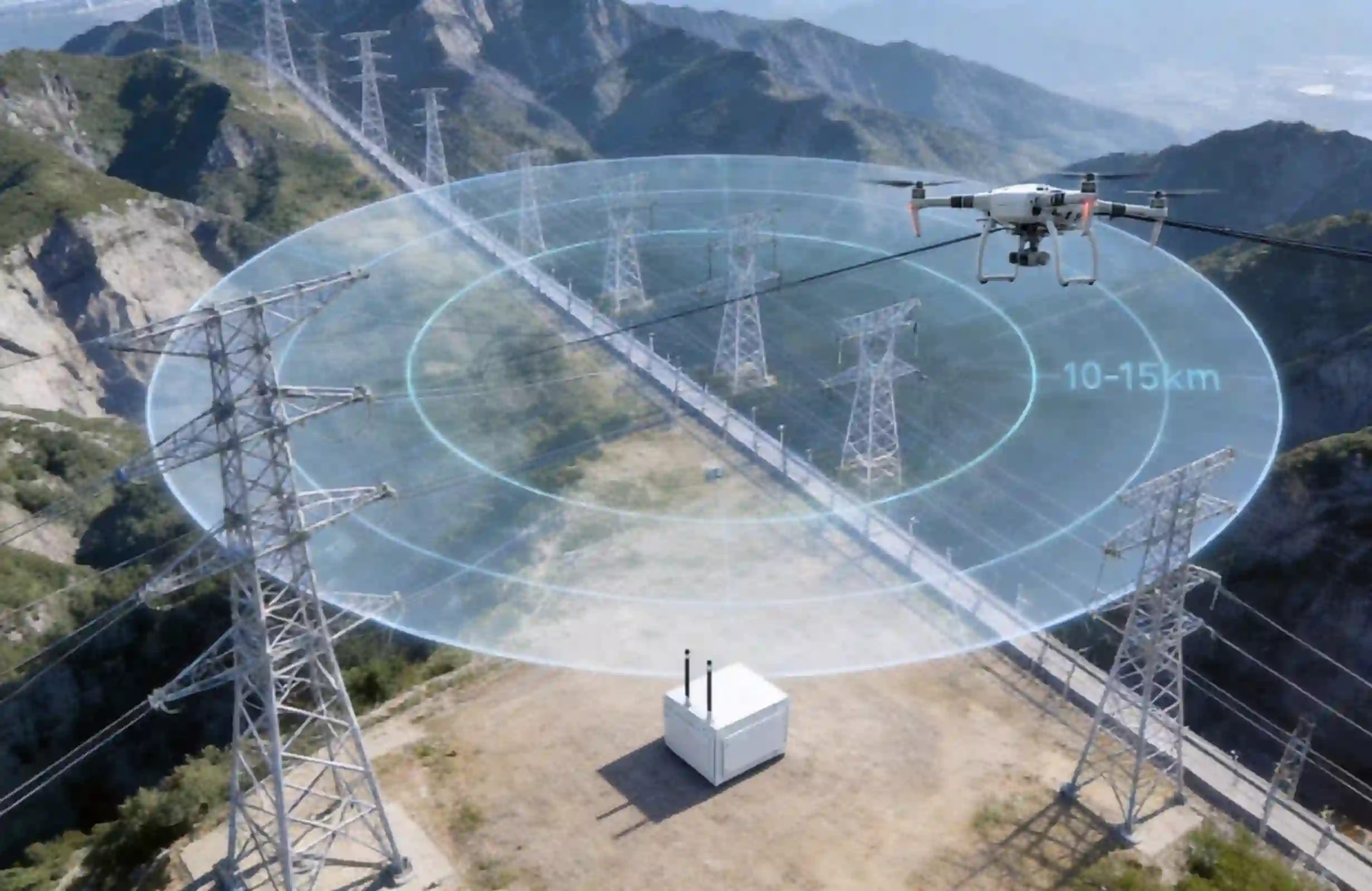
A drone hub functions as an automated base for industrial drones. The system integrates auto-charging, remote communication, weather sensing, and precision takeoff and landing capabilities. Teams deploy drone hub units along mountainous UHV corridors on hilltops, near communication towers, or at maintenance stations. This deployment establishes permanent aerial presences in uninhabited zones. An efly drone hub further reduces deployment barriers in complex mountain environments. Operations personnel no longer require professional pilot certifications. Staff members configure flight routes through a backend system. Consequently, the drone hub executes all tasks autonomously from that point. The approach transforms how power companies manage remote infrastructure.
Key Application Scenarios
Scenario 1: Routine Autonomous Patrol in Uninhabited Areas
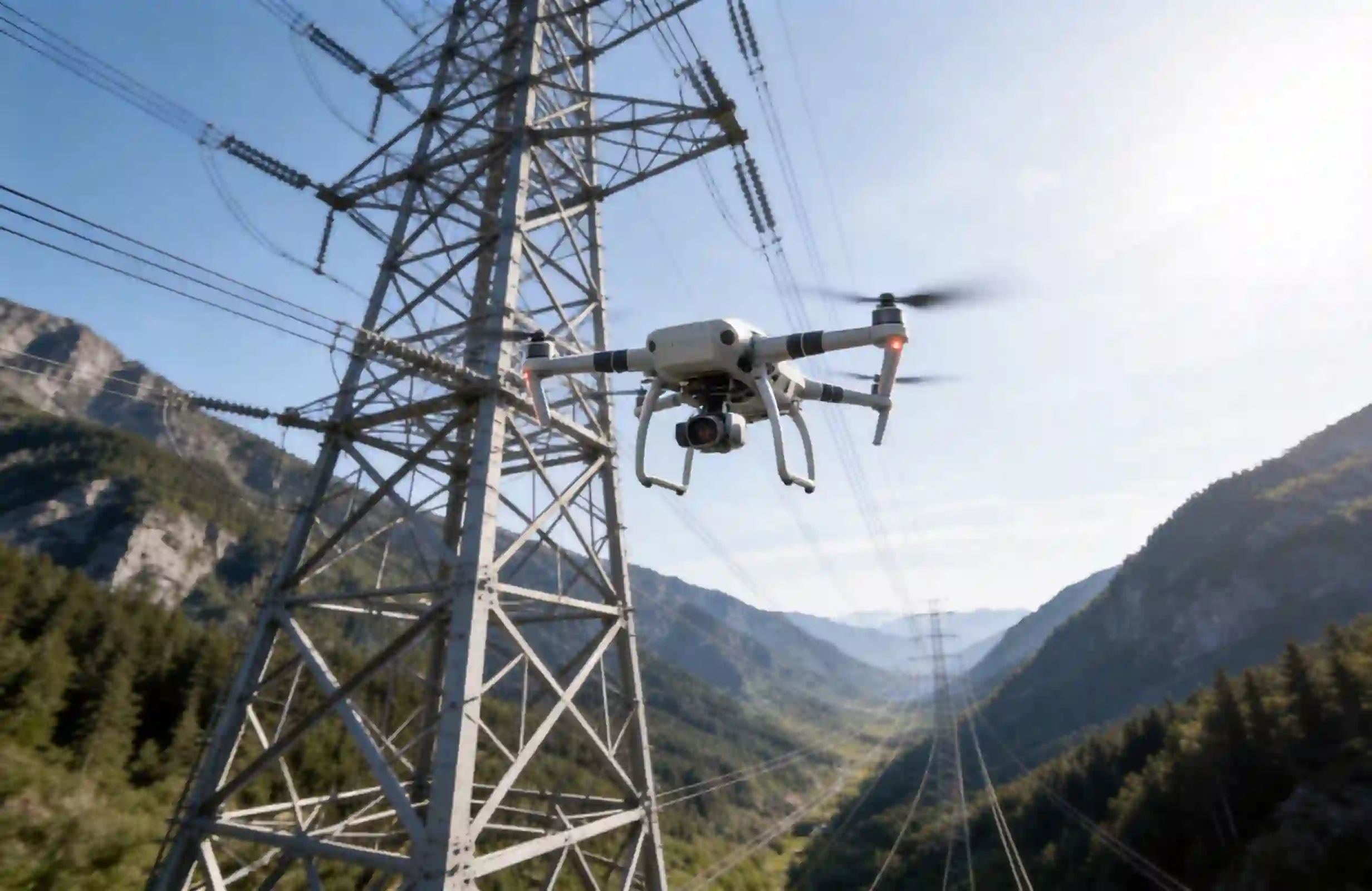
Power companies deploy one drone hub every 10 to 15 kilometers along UHV corridors. Each unit conducts daily autonomous flights along preset routes. Drones capture visible-light and infrared imagery of towers, insulator strings, conductors, hardware fittings, and corridor vegetation. AI algorithms analyze the imagery automatically. The system identifies defects including missing pins, damaged insulators, tree encroachment, and landslide indicators. This drone inspection approach delivers consistent monitoring regardless of weather or terrain conditions. Therefore, grid operators achieve comprehensive coverage previously impossible with manual methods. Specifically, critical infrastructure receives thorough examination without human risk.
Scenario 2: Post-Extreme-Weather Special Patrol
Severe weather events include heavy rain, gales, ice accumulation, and snow. These events create maximum vulnerability for UHV lines. When conditions permit, drones launch immediately from their drone hub stations. The aircraft conduct initial damage assessments while personnel remain safely at base. This capability eliminates dangerous post-storm field deployments. Grid operators receive accurate damage reports within hours instead of days. Rapid assessment accelerates restoration efforts significantly. Additionally, drone inspection provides critical data for insurance and regulatory compliance. Meanwhile, emergency response teams prioritize repairs based on real-time intelligence.
Scenario 3: Wildfire and Geological Hazard Monitoring
Thermal imaging and visible-light cameras enable comprehensive corridor surveillance. Drones scan designated areas at high frequency throughout danger seasons. The systems detect emerging hazards such as wildfires, active landslides, and ground subsidence. Early detection through drone inspection allows preventive action before disasters damage critical infrastructure. Notably, this proactive monitoring approach protects both the grid and surrounding communities. Thus, the technology serves broader environmental safety objectives.
Value Comparison
Traditional manual inspection requires officers to hike or use off-road vehicles to reach tower locations. This access method consumes significant time and resources. Annual inspection frequency reaches only two to four visits per year due to logistical constraints. Each tower inspection requires two to four hours of dedicated attention. Personnel face high risks from mountain terrain, altitude exposure, and weather hazards. Data quality varies based on individual inspector experience and vigilance. In contrast, automated systems deliver uniform results every time.
Drone hub-based unattended inspection changes this paradigm entirely. Drones fly directly from stations to tower locations without ground access requirements. Inspection frequency increases to one or two flights per day at each station. Tower inspection time drops to five to ten minutes per unit. Personnel risk approaches zero since operators remain at control centers. AI processing ensures consistent data quality through standardized flight paths and automated defect comparison. Thus, an efly drone hub investment delivers substantial operational improvements. Overall, the technology pays for itself through reduced accidents and improved grid reliability.
Deployment Recommendations
Successful drone hub implementation requires careful planning across several dimensions. Site selection should prioritize high-risk sections characterized by difficult access and frequent natural hazards. Coverage spacing typically allows a 10 to 15 kilometer effective radius per station. Adjustments depend on local terrain complexity. Power supply systems should combine solar panels with battery storage for reliable autonomous operation. Communication infrastructure needs satellite links or 4G/5G backhaul for continuous connectivity. Equipment selection must favor industrial-grade efly drone hub platforms offering strong electromagnetic interference protection and RTK positioning accuracy. These specifications ensure dependable autonomous function in harsh mountain environments throughout all seasons. Ultimately, proper planning maximizes return on investment and system longevity.
Mountainous UHV line inspection continues evolving from people walking ridges to drones watching the grid. Unattended patrol represents current reality, not future vision. This technology transformation delivers measurable improvements in safety, coverage, and response time for power grid operators managing critical infrastructure.